Open-pit uranium mining likely for area six miles northeast of Fort Collins city limits
75% of potential open-pit properties are within proposed growth management area of Town of Nunn
Updated October 28, 2007
NOTE: This page has been modified in response to the written threat of a defamation lawsuit from Powertech Uranium Corporation by adding the following explanatory language:
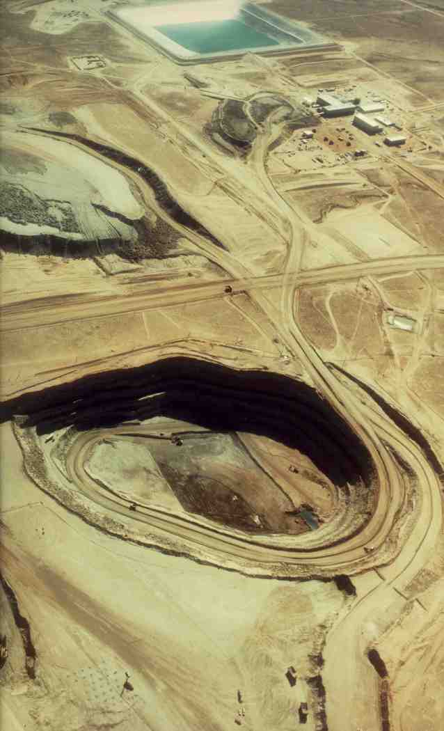
Several documents on this website verify the fact that Powertech is considering open pit uranium mining on up to four different sections of land located between Weld County roads 100 and 92. The southernmost section is about six miles from the city limits of Fort Collins. Since most people may have never seen a photograph of an open pit mine, I posted the photo below of the Sweetwater open pit uranium mine in Wyoming. Powertech officials object to the posting of this photo, and have threatened to sue me if I don't immediately remove it and post a retraction:
"The Sweetwater Mine aerial photo is misleading. The photo shows an area many times larger that any area under consideration for open pit gravel and uranium recovery in the Centennial Project. The image gives an inaccurate impression of possible geologic impacts associated with the Centennial Project in Weld County. Moreover, Powertech has not yet determined how uranium in the southern portion of the Centennial Project will be recovered." (Source: October 16, 2007 letter from Richard Blubaugh to Jim Woodward)
Powertech has yet to release any information regarding the size of these potential open pit mines. We do know that the uranium deposits in this area are 85-125 feet below the surface. The Sweetwater pit is currently owned by Rio Tinto Energy America (RTEA) and has been reclaimed as a 60-acre lake. According to the 2005 "Social and Environmental Report" from RTEA, the lake is 115 feet deep. If Powertech's open pit mines would be "many times" smaller than the Sweetwater pit, the company should release estimates of the dimensions of these mines. Furthermore, Powertech should release information regarding "possible geologic impacts" of these potential open pit mines.
Until Powertech releases detailed information about its plans for open pit uranium mines, the Sweetwater pit photo will remain, with the following qualification:
THE PHOTO BELOW MAY NOT BE AN ACCURATE REPRESENTATION OF POTENTIAL OPEN PIT URANIUM MINES PLANNED BY POWERTECH URANIUM CORPORATION. JW
Powertech documents show that the company may apply for permits to conduct open-pit uranium mining on one or more of four sections of land in Weld County, Colorado. The sections are (map):
Range 67 W, Township 9 N, Section 35 (Between CR98 & CR 100, and CR21 & 23)
Range 67 W, Township 8 N, Section 3 (Between CR96 & CR 98, and CR19 & 21)
Range 67 W, Township 8 N, Section 11 (Between CR94 & CR 96, and CR21 & 23)
Range 67 W, Township 8 N, Section 15 (Between CR92 & CR 94, and CR19 & 21)
Below is a 1980 aerial photo of the Sweetwater open-pit uranium mine near Rawlins, Wyoming. The mine property is currently owned by Rio Tinto Energy America.